
#SecretHistory calling the bluff of Pakistan. This was the map. Source: UK National Archives. 4th June 1947 (CAB 21/2038) 🧵

The map with blank area is where the local legislative assembly were to decide. I have numbered it.

Now history lessons for all of you. What were each of these areas numbered deciding?
Only Punjab and Bengal were deciding the partition of their own areas! (1 and 2 in map) (This partition happened in legislative assemblies)
If Bengal decided to partition, Sylhet(3) would decide between joining either Hindustan or Pakistan! (Since Bengal partitioned Sylhet joined Pakistan, again this was in legislative assembly)
If Punjab decided for partition, NWFP (4) would decide between Hindustan and Pakistan.
Sindh (5) and British Baluchistan(6) were deciding between Hindustan and Pakistan.
Now look at what was Hindustan! It is the gray shaded area.

Then check the area hashed like this. These were 500 princely states who were not part of this deal at all. These princely states could continue whatever they wanted to do. So, king had ultimate authority.

Now check what was the plan for Kashmir? Kashmir was never part of the partition. That means King would decide. And King decided to join India!
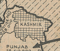
So, when King decided to join it should be end of the story.
Now what about Baluchistan. See how it is completely outside this. In fact, has the same legend as Tibet, Nepal or Bhutan. So Balochistan is actually never part of Pakistan!
