
There's a LOT of hype at the moment for Google DeepMind's AlphaEarth Foundations. But despite what you may have heard, Google wasn't the first to do this. Here's what came before, and what AEF does differently.

First, if you're interested in getting an intuitive breakdown on AEF, you might want to check this post out first: https://x.com/yohaniddawela/st...
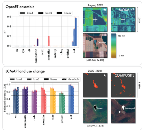
1. MOSAIKS (2021) It was one of the earliest general-purpose satellite embedding approaches. It uses random convolutional filters to create 1024-dimensional representations from RGB imagery.

2. SatCLIP (Microsoft, 2023) Uses contrastive learning to match satellite images with their geographic locations. It's trained on 100,000 Sentinel-2 images and creates 256-dimensional embeddings. But it only works with location data - no temporal information.
3. Prithvi (IBM & NASA, 2023) Prithvi is a Vision Transformer based model trained on multi-frame video clips from Harmonised Landsat-Sentinel imagery. It produces 768-2304 dimensional embeddings depending on available frames.
It handles time-series but is limited to 3 frames and trained only on American imagery. It handles multiple satellite sources and produces 768-dimensional embeddings. I describe Prithvi in more detail here: https://x.com/yohaniddawela/st...
4. Clay (2024) Clay uses a masked autoencoder (MAE) architecture to reconstruct inputs from Sentinel-1, Sentinel-2, Landsat, MODIS, NAIP, and LINZ. It supports any input size, number of bands, and resolution.
Clay also includes: • A dynamic embedding block that adapts to spectral characteristics • Positional encoding based on latitude, longitude, time, and resolution • A DINOv2 teacher to improve learned representations It was trained on 70M global chips from diverse land covers.
Clay performed quite well in Google's benchmarks, however they actually didn't use the most recent version (v1.5). So I suspect the newer model would perform even better.
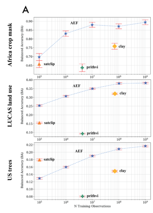
So what does AlphaEarth Foundations do differently? It combines: • Continuous time modelling • Multiple sensor types (optical, radar, LiDAR, climate, text) • 10m spatial resolution • One compact 64-byte embedding • Global coverage from 2017–2024
According to its paper, it outperforms all previous models on many tasks: land use, crop type, evapotranspiration, and more. However, it would be good to see these benchmarks against the LATEST foundation models (e.g. Clay v1.5).
There's actually a big debate on whether these foundation models are all hype or no substance. If you're interested in learning more, check this out: https://x.com/yohaniddawela/st... And give us a follow @yohaniddawela for more breakdowns on geospatial topics.
Interested in getting a short overview of the latest geospatial papers and datasets each week? Subscribe to the Spatial Edge newsletter: http://yohan.so
@yohaniddawela @sabman is working on http://earthgpt.app which plans to incorporate some of these models
@yohaniddawela My (RichardKCollin2, The Internet Foundation) comment on Yohan's post: Yohan, thank you for sharing. Saves time for me and others. These problems are many decades old. Only sensors, computers, memory and data limited the past. The first analysis steps were obvious long ago, but
🚀 New Tutorial Alert! I just published a step-by-step guide on building an interactive dashboard with Python and Leafmap. 🌍📊 Explore the Jupyter Notebook: https://leafmap.org/maplibre/d... Watch the full video tutorial: https://youtu.be/DEPdsJdTQN8 #leafmap #geospatial #python #dataviz
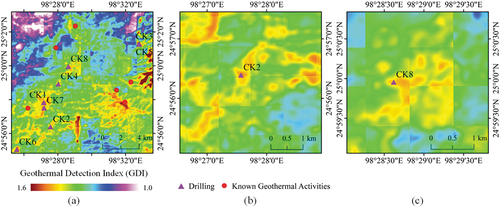
😲Traditional field investigations struggle to detect #geothermal potential areas! But a breakthrough is here! Researchers integrated remote-sensing data to improve temperature data resolution and developed a Geothermal Detection Index (GDI) with PCA. This novel method
Google #EarthEngine Tutorial-151 Published: #Landsat-#Sentinel Crop Phenology Analysis, using Python API (#Xee) https://youtu.be/6XPNIhf-qpQ
Tree Canopy Height of Minneapolis
